Michelsberg Earthwork in Jülich
Michelsberg Earthwork
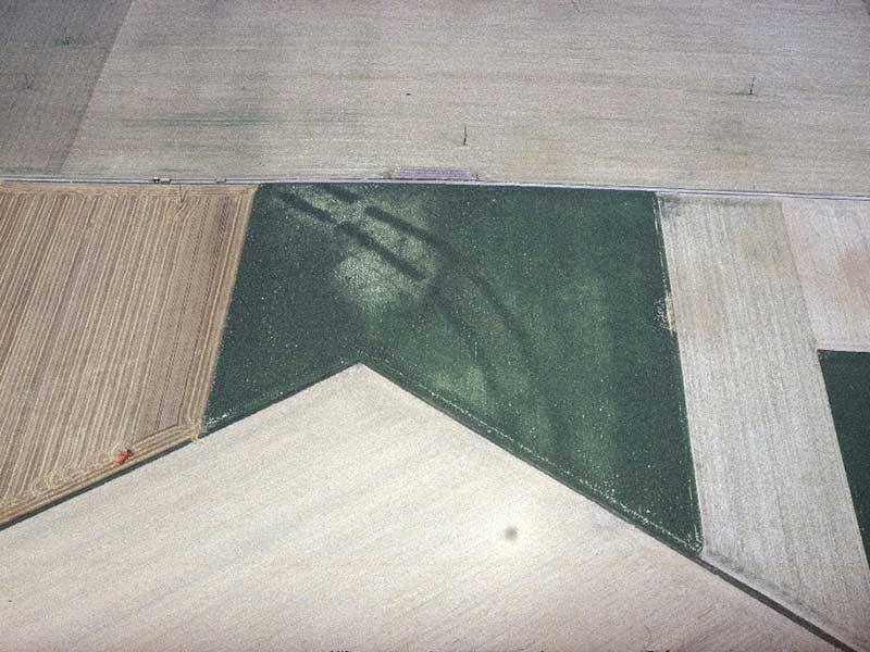
A true chance discovery: in the late 1960s, a pilot spotted the earthwork of Jülich-Stetternich during a flight. In the farmland below, he saw two massive, parallel dark strips stretching over several hundred meters and interrupted at certain points. Through targeted aerial surveys, systematic fieldwalking, and geophysical measurements, experts were able to investigate this relic from the Neolithic period.
Long before the development of a systematic road network, a system of routes oriented toward the natural landscape had already emerged, some of which were later incorporated into Roman road construction. In the Jülich region, there is a striking concentration of three earthworks of the Michelsberg culture, spaced about five kilometers apart along the line of the later Via Belgica. The largest and youngest of these installations (dating to around 3500–3000 BC), with a diameter of about one kilometer, lies along the հատված between Stetternich and Jülich.
An earthwork is an enclosed area defined by ditches—often also by ramparts and palisades. The interruptions in the ditches are earthen bridges, or gate openings, through which access to the interior was possible. The ditches were up to ten meters wide, and the distance between them was approximately 15 meters. In total, the oval area—including both the ditches and the interior—covered around 36 hectares.
However, the function of the Michelsberg earthworks remains unknown. It is assumed that they may have served the surrounding settlements as marketplaces and meeting places, refuges, or livestock enclosures. By the time the Via Belgica was built in the Roman period, nothing of the Stetternich earthwork was still visible—until that significant flight in the 1960s…
Fun to know
- Photo: the surrounding ditches of the earthwork are visible from the air. Photo: G. Amtmann, LVR Bureau for Archaeological Heritage Management