Rotbach crossing in Erftstadt
Rotbach crossing
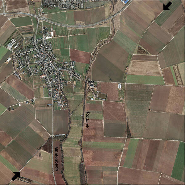
During an archaeological excavation on the edge of Agrippastraße, twelve cremation graves dating from the 2nd and 3rd centuries AD were discovered. This suggests that a Roman villa rustica or other Roman settlement was located nearby. So far, however, its location has not been determined, but it may lie further east near the Rotbach stream. Numerous examples document the establishment of Roman settlements at river crossings. Clay is frequently deposited along the banks of bodies of water – ideal conditions for establishing a pottery workshop.
South of Ahrem, the Agrippa Road crosses the Rotbach stream, formerly known as the Bleibach, for the first time. The Rotbach is heavily regulated at this point. To the west runs the Lechenich millrace, the former Rotbach. The course of the Roman road is visible from the air in the surrounding fields; east of the Rotbach, it is marked in the fields as an embankment. A ditch now runs between the two waterways, precisely following the route of the Roman road.
The production of ceramics in this region is evidenced by a pottery kiln found near the cremation burials; a geophysical survey on the west bank of the millrace revealed the locations of further kilns. Another pottery workshop was found further upstream near Friesheim.
The Lechenich millrace once powered several watermills. A continuous flow of water was essential for this: water was diverted from the Rotbach stream using a weir. The former town mill (Oebelsmühle) of Lechenich is also located on the Lechenich millrace. The mill, which once belonged to the Archbishop of Cologne, was first mentioned around 1293 and served for a long time as a compulsory mill.
Fun to know
- Photo: aerial photo of the Via Agrippa near Ahrem. Geobase data of the municipalities and the state of North Rhine-Westphalia: © Geobasis NRW