Roman Road and Vicus Iuliacum in Jülich
Roman Road and Vicus Iuliacum
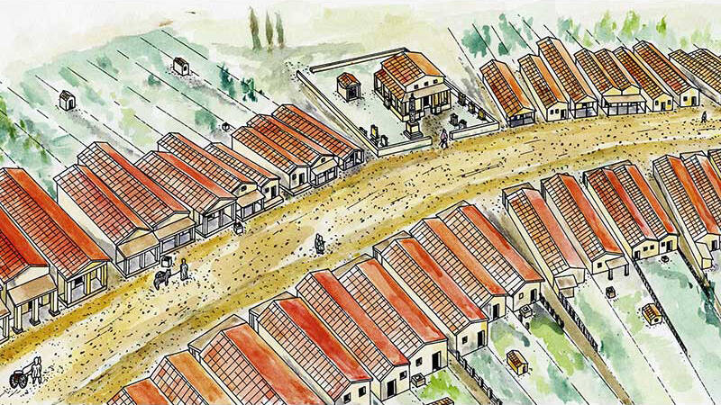
On this perfectly straight section of the Via Belgica between Jülich and Cologne, the Roman settlement of Iuliacum (Jülich) developed in the marshy lowlands of the Rur. The civilian settlement, initially unfortified, covered about 13 hectares along the road. On both sides of the roadway, made of compacted gravel, so-called strip houses were built—narrow buildings with their gable ends facing the street. Some rooms in these houses had underfloor heating (hypocaustum), and in some cases, the walls were decorated with paintings. At the fronts of the houses, there were partially covered sales areas.
The inhabitants of Iuliacum buried their dead along the road in front of the settlement. The “sarcophagus” on the castle square is actually a Roman ash chest, a container for the remains of a cremation. It was found in Kirchberg and erected here in 1904.
The Via Belgica between Cologne and Jülich was an important transport route, which continued to be heavily used as the B55 well into the last century. It made Jülich a strategically significant location in the Rhineland. It is therefore no coincidence that the town looks back on a long tradition as a fortress city. The late Roman fort, the medieval town, and the early modern citadel are just three stages in a history of fortifications that extends into the 19th century.
Today, the route of the Via Belgica east of Jülich is interrupted by open-cast mining; only the last section follows the Roman road. There, it is called Römerstraße—its asphalt lies almost two meters above the gravel of the Via Belgica.

Fun to know
- First photo: the narrow strip houses are typical buildings of a Roman roadside settlement (vicus) such as Jülich (Iuliacum). Graphic design: M. Perse, drawing: M. Najdul
- Second photo: landscape of the Roman road Via Belgica outside the settlements. Graphic design: M. Perse, drawing: M. Najdul